Monday, April 19.
9.7 miles.
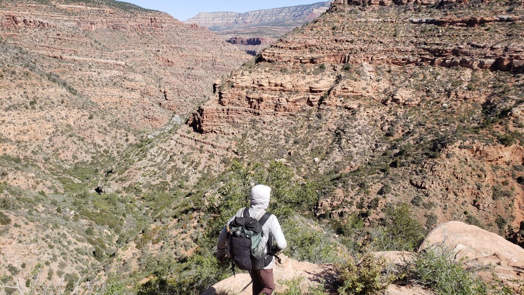
Saddle Canyon, the most arduous and difficult section of the Hayduke Trail. I’ve read so many journals that talk about how hard and slow this section is and I’ve been anxious about it for weeks. I even tried to talk to the ranger a few days about finding a bypass using dirt roads. And this ended up being my favorite days on the Hayduke and one of my favorite days on any trail ever.
Got a good start by getting a good night’s sleep. The cot I was on was really squeeky and everytime I moved it went ee ee but I still manged to sleep okay. At least it was warm and the mice didn’t seem to get my food (hung it from a rusty nail in the wall).
I went back and found the seep I couldn’t find last night. It was actually just a little further down the trail I was on, just gave up looking a little too early. Filtered and filled up 2 liters of water thinking that’s be enough for the day.
From the cabin we followed a little use trail to a wash that was filled with thick thorny shrubs and branchy trees. Everything tried to stab me and tear off my clothes. The pants I got in Escalante held up well and surprisingly so did my wind shirt. I had commited to sacraficing it to keep the rest of my clothes protected but Saddle Canyon was forgiving today.
The thorny bushwhack wasn’t too bad. It was slow going down the wash, weaving our way through the trees and bristle trying to avoid getting poked as much as possible. We reached a burn area where it opened up a bit and the bushwhacking stopped. This might be new since I hadn’t read about it from any other blogs.
We reached a few pour offs that were easy enough to scramble down or go around. On one of them Jack did topple forward a bit and banged up his shin. Little lost skin and blood but nothing too serious. Saddle Canyon had to take its blood toll. Blood for the blood god. Rowan turns out is a little bighorn sheep and he just jumped right down all the pour offs making the rest of us look bad. Think he might be a more serious climber so this stuff was easy for him.
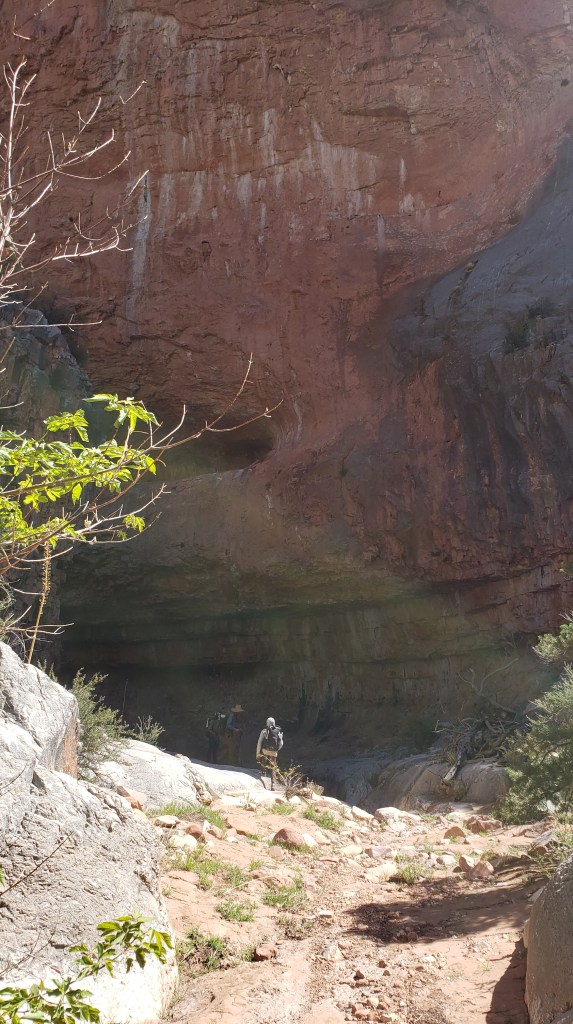
We reached an impassable pour offf that required a bypass. Rowan went right into the pour off and found a path all the way down that in his words was pretty sketchy. Jack, Jordan, and I opted for the higher bypass. I had read from other blogs to not go too high up on the bypass and not follow the GPS tracks exactly. We started heading up and found a use trail with a few cairns that lead us across a slope to a saddle. The guidebook directions and Skurka’s maps say to “climb to spit of land” and we have no idea what the fuck spit of land means but I think we did it. From the saddle we dropped down into a drainage that lead us to another slope we followed down to the canyon floor. We went down that for a bit but reached another slickrock pour off that we had to go around. It took us a while but we reached the floor of the canyon finally and found Rowan who had been there for a while it seems. The impassable pour off is maybe not so impassable.
Note about the impassable pour off: describing route beta is hard without pointing to a map and or showing the features in person but let’s just say that the few cairns are very useful and enough hikers had gone through it that there’s a use trail clear enough to follow all the way down. Don’t go too high up above the impassable pour off and get cliffed out. I think this is an instance where the Skurka maps were more useful than any of the GPS tracks we had.

After the pour off, the canyon started narrowing and we got into the plunge pools section. Other blogs talked about how deep these pools were and how they had to keep sliding into them. We managed to avoid pretty much all of them except for the last two. I think it helped that this region had been in a drought for two years and there wasn’t much water running through here. It’s also been pretty cold this week so there hasn’t been much snow melt too. A lot of the plunge pools were dried up but we could see the water lines they got up to. The few remaining pools where mostly easy enough to go around, usually by walking on a narrow slickrock ledge above them.

There was one pool where the bypass looked too sketchy for us (except Rowan who is a goat) so we had to get out feet wet. The pool wasn’t too deep or cold but it did get my shoes wet which made them less stable on the slickrock. Coming down some not so steep slickrock, I slipped and slid down pretty hard. Didn’t get too hurt except for my pride and my constantly abused left knee.
The last plunge pool was a straight up waterslide. We all had to slide down into a shallow pool. It looked pretty intimidating from above but Jordan did it and it wasn’t that bad. I tweaked my ankle a bit doing it with no hands (and no brakes) but it was fine the rest of the day. Just a little something I need to keep an eye on.

There was one more large pour off that required another bypass. We traversed a high up ledge then dropped down a loose slope to the bottom of the pour off. This one was massive and there was no way down it, not even for Rowan.

We exited Saddle Canyon, not too beat up but a little wet and had lunch. I need to never read trail journals again. Saddle Canyon was tough, absolutely, but I definitely psyched myself out reading so much about it. To anyone reading this as prep for the Hayduke: Saddle Canyon is tough but it’s not so bad. Maybe learn to down climb beforehand though.
From there we got into the Tapeats Creek area. The water source was actually a mile from the spot listed in the water chart and databook and I hadn’t grabbed more in the plunge pools since I thought we’d be reaching some soon. Nope. As soon as the canyon opened up, it got hot af. I was almost out of water but Jack generously offered me some of his. Jordan constantly makes fun of Jack for carrying too much water but I was grateful he had it. Not that I needed it through since the creek started flowing right after.
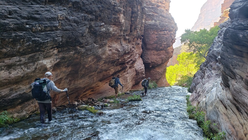
Tapeats Creek really gets flowing at the Tapeats Spring confluence. Tapeats Creek is also another really dramatized spot which warnings of difficult crossings, fast water, and possible death. Yeah, it wasn’t that bad either. Again, I think the weather we’ve had (low precip, cold temps) made it so the creek wasn’t flowing as fast as it might be when there’s more run off. Don’t get me wrong, it was still incredibly fast at points and falling and getting swept down was a real possibility at certain points. We did have to cross the creek a few times but there is now a very well maintained and cairned trail that is pretty easy to follow and leads to the easier to cross sections. It also helps that there were four of us in case we needed to help one another cross.
Tapeats Creek is fucking gorgeous by the way. The canyon walls narrow at times and you have to walk down the creek alongside beautiful tall redstone walls and Tapeats ledges. It’s so pretty.
Rowan and Jack found a swimming hole below a little waterfalls and of course we sent it.
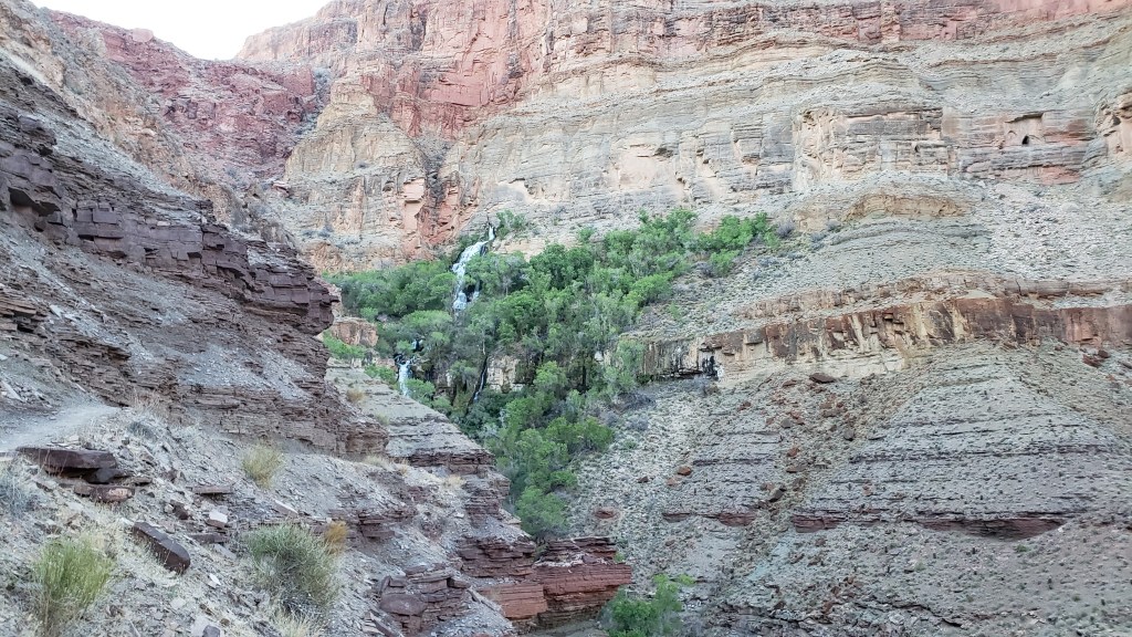
We followed Tapeats to its confluence with Thunder River, the world’s shortest river. There was an actual trail to follow, one that was on maps and everything, and we hopped on that up towards the headwaters of the Thunder River, half a mile up. The headwaters is just a big whole in the side of the canyon where there’s a giant spring that gushes out so much water. How is it possible for so much water to just come out of a canyon wall like that…? We had dinner at a rocky outcrop that overlooked the waterfall. I had refried beans I found at the south rim village store and an Avocado I had packed out. Beans + Avocado + Nooch + hot sauce = the best meal I’ve had on the Hayduke. We even had company while we ate when a Bighorn Sheep got really close to us. We’ve had some great wildlife encounters in the past two days. First the bison and now the sheep.
We took a side trail to the base of the waterfall below the spring and it was so majestic and wonderful. I was legit enraptured by this waterfall, how it just came out of the wall and flowed down so powerfully for such a short distance.
The climb up to the waterfall/headwaters of the Thunder River was pretty steep and kept going up to a valley which was more of an open plateau. There we found an amazing campsite with 360 views of the Grand Canyon. We could see down where we had spent all day and all the mesas around us. Goddamn it’s so cool.

We set up camp and Jack regaled us with names of stars and how relativity works. We’re cowboy camping, as Jordan and I do most nights, but tonight feels special. We experienced so much in a single day, so much filled into just 12 hours. Less than 10 miles but maybe the most adventurous and scenic and magical and difficult and worthwhile miles I’ve ever had. Really glad we didn’t skip this part.

